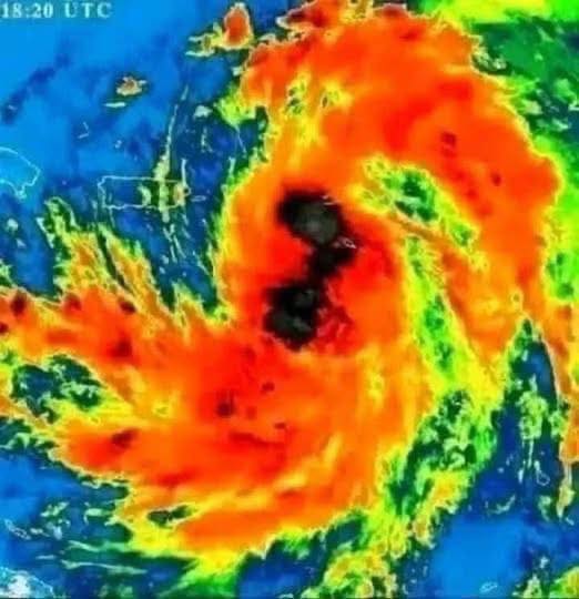
The Atlantic hurricane season of 2025 has already brought significant activity, and now attention has turned to a developing disturbance in the northwestern Caribbean Sea. The National Hurricane Center (NHC) has identified a broad area of thunderstorms and unsettled weather, signaling the possibility of a tropical cyclone forming within the next 24 to 48 hours.
Forecasters note that conditions appear favorable for strengthening. If organization continues, the system will likely be given the name Helene once it achieves tropical storm status. Its projected path could carry it through the Yucatán Channel and into the Gulf of Mexico, where warm waters and supportive atmospheric conditions may allow for rapid intensification before eventual landfall.
This situation reminds many residents and officials of past storm seasons when disturbances in the Caribbean quickly transformed into hurricanes that affected the Gulf Coast. While uncertainty remains, the system demands close attention and preparation from communities in its potential path.
Current Advisories: What Forecasters Are Saying
The NHC has issued updates highlighting a high probability of development. Meteorologists currently estimate around a 70% chance that the disturbance will become a tropical depression or storm within the next two days.
Key elements from current forecasts include:
- Projected Track: Movement northward across the northwestern Caribbean, then through the Yucatán Channel.
- Strength Potential: Likely intensification over the Gulf of Mexico, possibly reaching hurricane status.
- Timing: Organization expected later today or overnight, with continued monitoring for rapid development.
Such advisories serve as an early signal to governments, emergency planners, and residents that proactive steps may soon be necessary.
Why Conditions Favor Development
Several environmental factors are aligning to make this system more likely to strengthen:
1. Warm Sea Surface Temperatures
The Caribbean and Gulf of Mexico currently feature above-average sea temperatures. These warm waters provide the primary energy source for tropical cyclones, enabling them to gather strength quickly.
2. Low Wind Shear
Wind shear—changes in wind speed or direction with height—can disrupt storm organization. Right now, shear levels are relatively low, creating a favorable environment for a storm’s vertical structure to develop.
3. Moisture-Rich Atmosphere
The atmosphere above the disturbance is moist and supportive of deep convection. Clusters of thunderstorms continue to form and persist, showing signs of organization.
4. Evolving Circulation
Satellite observations suggest that a mid-level gyre may be consolidating into a more defined low-level circulation, a key precursor to cyclone formation.
Together, these ingredients make it highly probable that the disturbance will transition into a named storm.
Lessons From History: The Case of Helene in 2024
Meteorologists often look to history for parallels. In September 2024, a system with a nearly identical origin followed a similar track. That disturbance began as “Potential Tropical Cyclone Nine,” eventually becoming Hurricane Helene, which rapidly intensified into a Category 4 hurricane before making landfall in Florida’s Big Bend region.
That event left a powerful impression:
- Storm Surge: Entire coastal towns faced devastating flooding.
- Rainfall: More than 10 inches fell in some regions, leading to widespread flash flooding.
- Fatalities and Damage: Over 120 lives were lost, and economic damage exceeded billions.
While no two storms are identical, the similarities in environmental conditions mean that communities now watching the current disturbance cannot ignore the risks.
Potential Impacts if Strengthening Continues
If the disturbance evolves into Hurricane Helene, multiple hazards could threaten Gulf Coast states.
Storm Surge and Coastal Flooding
Low-lying areas along Florida’s Big Bend, western Panhandle, and the Suncoast may face storm surge exceeding 2–4 feet or more, creating dangerous flooding conditions.
Heavy Rainfall and Flash Flooding
Forecast models suggest rainfall totals of 3–6 inches, with some areas possibly experiencing up to 10 inches. Urban areas, river valleys, and flood-prone zones are especially at risk.
Strong Winds
Should rapid intensification occur, hurricane-force winds could spread across a wide region. Such winds can damage buildings, topple trees, and disrupt power infrastructure.
Tornado Risk
Tropical systems often produce tornadoes within their outer rainbands. Areas across southern Georgia and the Carolinas may face an increased risk even if the storm’s center remains further west.
Broader Inland Effects
Even after landfall, the storm’s expansive wind field and heavy rainfall could extend far inland, impacting states such as Georgia, South Carolina, and parts of northern Florida.
How Communities Can Prepare
Preparation remains the most effective way to minimize risk. Authorities encourage residents in potentially affected areas to:
- Monitor Official Updates: Follow NHC advisories, local emergency management, and trusted news outlets.
- Plan Evacuations: Know evacuation routes and shelter options. Consider the needs of pets, elderly family members, and those with medical conditions.
- Secure Properties: Protect windows, remove loose outdoor items, and ensure that roofs and doors are reinforced.
- Gather Essentials: Stock supplies such as non-perishable food, clean water, medications, flashlights, batteries, and radios.
- Stay Connected: Keep phones charged and establish family communication plans.
Proactive steps taken early reduce stress and improve safety if conditions worsen.
Advances in Forecasting: A Growing Science
Forecasting hurricanes has always been a challenge, but recent scientific advances are improving accuracy.
For example, research in 2025 introduced probabilistic neural network models that better capture forecast uncertainty. These tools outperform traditional methods by dynamically adjusting to evolving conditions, giving forecasters and the public more reliable guidance.
This progress means that communities can prepare with greater confidence, even when storm tracks shift.
Climate Background: Why the 2025 Season Is Active
The 2025 Atlantic hurricane season is shaping up to be above average, with the NOAA outlook predicting up to 19 named storms, 6–10 hurricanes, and 3–5 major hurricanes.
Contributing factors include:
- Warm Ocean Temperatures – fueling storms more efficiently.
- Lingering La Niña-Like Patterns – influencing wind patterns that favor development.
- Long-Term Climate Trends – linked to increased storm intensity and frequency.
These elements highlight why vigilance is particularly important this year.
Comparisons With Other Storms
The Caribbean-to-Gulf development pathway has produced several notable systems in recent years, including:
- Tropical Storm Alberto (2024) – formed above the Yucatán before striking Gulf states.
- Tropical Storm Chris (2024) – crossed into the Bay of Campeche, where it intensified.
- Hurricane Enrique (2021) – developed from disorganized cloud clusters before strengthening over warm waters.
Such precedents illustrate how seemingly minor disturbances can escalate into impactful storms.
Key Takeaways for Readers
- The disturbance is likely to be named Helene within 48 hours.
- Path forecast: Through the Yucatán Channel into the Gulf of Mexico.
- Strength potential: Rapid intensification into a Category 3+ hurricane is possible.
- Impacts: Strong winds, storm surge, flooding, and tornadoes are all concerns.
- Action required: Stay informed, prepare emergency supplies, and follow official instructions.
Looking Ahead
At present, the disturbance remains broad and only partly organized. However, all signs indicate that development is imminent. After passing through the Yucatán Channel, the system may encounter nearly ideal conditions for intensification over the Gulf of Mexico.
Whether it becomes a strong tropical storm or a major hurricane, its influence could spread across multiple states, both coastal and inland. The best defense for residents is early awareness and preparation.
Final Thoughts: Staying Vigilant
Tropical weather systems remind us of nature’s unpredictability. Even when a storm is still in its formative stage, it has the potential to change lives and landscapes dramatically.
By studying the lessons of past hurricanes, improving forecasting accuracy, and encouraging personal and community readiness, we can lessen the impact of future storms.
As the 2025 season continues, this potential Hurricane Helene serves as a call to remain cautious, prepared, and united in response.